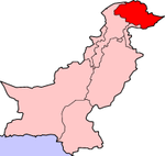
Balawaristán
Aparencia
| Localización | |||||
|---|---|---|---|---|---|
| |||||

Balawaristán (en urdú: بلاورستان) que quere dicir 'país de alturas', e un nome empregado pola xente da rexión administrativa paquistaní de Gilgit-Baltistán para facer referencia á súa rexión. O termo foi creado polo partido político paquistaní Fronte Nacional de Balawaristán, fundado porNawaz Khan Naji en 1989. O concepto ten as súas raíces nos nomes históricos Bolor ou Boloristan, cuxo uso está documentado en fontes chinesas do século VIII.[1] Segundo activistas políticos actuais, 'Balawaristán' inclúe Chitral, Gilgit, Skardu, Hunza, Nagar, Ishkoman, Punial e Yasin. O líder da Fronte Nacionalde Balawaristán, Nawaz Khan Naji, declarou que Balawaristán (Gilgit-Baltistán) non forma parte da rexión de Caxemir.[2]
Notas
[editar | editar a fonte]- ↑ Osterreichishe Leo-Gesellschaft, Görres-Gesellschaft, Anthropos Institute, Görres-Gesellschaft zur Pflege der Wissenschaften im Katholischen Deutschland, Bonn, Leo-Gesellschaft, Vienna (1984). Anthropos, v.79 no.1-6. Consultado o 2009-01-24.
A more indigenous label for the same territory is Bolor (or Boloristan); this designation had appeared in Chinese sources already in the 8th century.
- ↑ "Contested status | Political Economy | thenews.com.pk". www.thenews.com.pk (en inglés). Consultado o 2021-04-30.
Véxase tamén
[editar | editar a fonte]Bibliografía
[editar | editar a fonte]- Behera, Navnita Chadha (2007). Demystifying Kashmir. Pearson Education India. ISBN 8131708462.
- Sökefeld, Martin (2012). "Secularism and the Kashmir dispute". En Nils Ole Bubandt; Martijn Van Beek. Varieties of Secularism in Asia: Anthropological Explorations of Religion, Politics and the Spiritual. Routledge. pp. 101–120. ISBN 978-1-136-66864-7.

