

Portal:Mountains
| |
|
|
Introduction


A mountain is an elevated portion of the Earth's crust, generally with steep sides that show significant exposed bedrock. Although definitions vary, a mountain may differ from a plateau in having a limited summit area, and is usually higher than a hill, typically rising at least 300 metres (980 ft) above the surrounding land. A few mountains are isolated summits, but most occur in mountain ranges.
Mountains are formed through tectonic forces, erosion, or volcanism, which act on time scales of up to tens of millions of years. Once mountain building ceases, mountains are slowly leveled through the action of weathering, through slumping and other forms of mass wasting, as well as through erosion by rivers and glaciers.
High elevations on mountains produce colder climates than at sea level at similar latitude. These colder climates strongly affect the ecosystems of mountains: different elevations have different plants and animals. Because of the less hospitable terrain and climate, mountains tend to be used less for agriculture and more for resource extraction, such as mining and logging, along with recreation, such as mountain climbing and skiing.
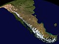
The highest mountain on Earth is Mount Everest in the Himalayas of Asia, whose summit is 8,850 m (29,035 ft) above mean sea level. The highest known mountain on any planet in the Solar System is Olympus Mons on Mars at 21,171 m (69,459 ft). The tallest mountain including submarine terrain is Mauna Kea in Hawaii from its underwater base at 9,330 m (30,610 ft) and some scientists consider it to be the tallest on earth. (Full article...)
Selected mountain-related landform

A drumlin, from the Irish word droimnín ("little ridge"), first recorded in 1833, in the classical sense is an elongated hill in the shape of an inverted spoon or half-buried egg formed by glacial ice acting on underlying unconsolidated till or ground moraine. Assemblages of drumlins are referred to as fields or swarms; they can create a landscape which is often described as having a 'basket of eggs topography'. (Full article...)
Selected mountain range

The Ligurian Alps are a mountain range in northwestern Italy. A small part is located in France. They form the south-western extremity of the Alps, separated from the Apennines by the Colle di Cadibona. The Col de Tende and the Vermenagna valley separate them from the Maritime Alps. They form the border between Piedmont in the north and Liguria in the south. (Full article...)
Selected mountain type

A mud volcano or mud dome is a landform created by the eruption of mud or slurries, water and gases. Several geological processes may cause the formation of mud volcanoes. Mud volcanoes are not true igneous volcanoes as they do not produce lava and are not necessarily driven by magmatic activity. Mud volcanoes may range in size from merely 1 or 2 meters high and 1 or 2 meters wide, to 700 meters high and 10 kilometers wide. Smaller mud exudations are sometimes referred to as mud-pots.
The mud produced by mud volcanoes is mostly formed as hot water, which has been heated deep below the Earth's surface, begins to mix and blend with subterranean mineral deposits, thus creating the mud slurry exudate. This material is then forced upwards through a geological fault or fissure due to local subterranean pressure imbalances. Mud volcanoes are associated with subduction zones and about 1100 have been identified on or near land. The temperature of any given active mud volcano generally remains fairly steady and is much lower than the typical temperatures found in igneous volcanoes. Mud volcano temperatures can range from near 100 °C (212 °F) to occasionally 2 °C (36 °F), some being used as popular "mud baths". (Full article...)
Selected climbing article

Altitude sickness, the mildest form being acute mountain sickness (AMS), is a harmful effect of high altitude, caused by rapid exposure to low amounts of oxygen at high elevation. People can respond to high altitude in different ways. Symptoms may include headaches, vomiting, tiredness, confusion, trouble sleeping, and dizziness. Acute mountain sickness can progress to high-altitude pulmonary edema (HAPE) with associated shortness of breath or high-altitude cerebral edema (HACE) with associated confusion. Chronic mountain sickness may occur after long-term exposure to high altitude.
Altitude sickness typically occurs only above 2,500 metres (8,000 ft), though some are affected at lower altitudes. Risk factors include a prior episode of altitude sickness, a high degree of activity, and a rapid increase in elevation. Diagnosis is based on symptoms and is supported for those who have more than a minor reduction in activities. It is recommended that at high altitude any symptoms of headache, nausea, shortness of breath, or vomiting be assumed to be altitude sickness. (Full article...)
Related portals
General images
-
 Iranian oak scrub in the Zagros Mountains (from Montane ecosystems)
 -
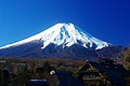 Fuji volcano (from Mountain)
 -
-
-
 This 1848 "Sketch showing the actual elevation of the Snow Line in different Latitudes" by Alexander Keith Johnston shows the snow lines of mountains in America, Europe and Asia (from Snow line)
 -
 Antique climbing tools (from Mountaineering)
 -
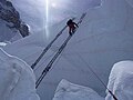 Fixed lines and ladders are distinguishing characteristics of expedition style mountaineering (from Mountaineering)
 -
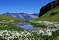
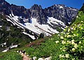 Alpine flora near Cascade Pass (from Montane ecosystems)
 -
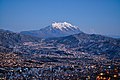
 Chimborazo, Ecuador, whose summit is the point farthest away from the Earth's center (from Mountain)
 -
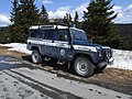 Car of Horská služba (Czech Republic) (from Mountain rescue)
 -
 Mount Everest, Earth's highest mountain (from Mountain)
 -
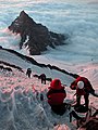
 Mountaineers proceed across snow fields on South Tyrol; other climbers are visible further up the slopes. (from Mountaineering)
 -
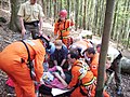
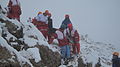 A mountain rescue team in Iran moving a casualty. (from Mountain rescue)
 -
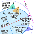 Everest is highest from sea level (green), Mauna Kea is highest from its base (orange), Cayambe is farthest from Earth's axis (pink) and Chimborazo is farthest from Earth's centre (blue) (from Mountain)
 -
 The Andes, the longest mountain range on the surface of the Earth, have a dramatic impact on the climate of South America (from Mountain range)
 -
 The northern Urals at high latitude and elevation have an alpine climate and barren ground. (from Mountain)
 -
-
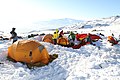 Winter campers bivouaced in the snow (from Mountaineering)
 -
 Tropical montane forest at around 2,000 m in Malaysia (from Montane ecosystems)
 -
Mountaineers climbing in South Tyrol (from Mountain)
-
-
-
 Choppering out the injured – with Mt. Forbes in the background (from Mountain rescue)
 -
 Mountaineers, c. 1900 (from Mountaineering)
 -
-
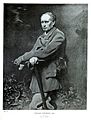
 British mountaineer William Cecil Slingsby became known as the father of Norwegian mountaineering and contributed greatly to its popularization with his classic book Norway, the Northern Playground (from Mountaineering)
 -
-
 Mountain rescue team members and other services attend to a casualty in Freiburg Germany. (from Mountain rescue)
 -
-
 The Namcha Barwa Himal, east part of the Himalayas as seen from space by Apollo 9 (from Mountain range)
 -
-
-
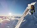 Climber approaching the summit of Manaslu at 8,163 metres (from Mountaineering)
 -
 Stretcher box in Cumbria, England, prepositioned equipment saves mountain rescue teams having to trudge up mountains with it. (from Mountain rescue)
 -
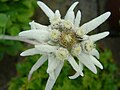 Edelweiss, a plant associated with mountain sports (from Mountaineering)
 -
-
-
-
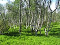 A stand of mountain birch at around 750 m in Trollheimen, typical of Scandinavian subalpine forests (from Montane ecosystems)
 -
 The Ocean Ridge, the world's longest mountain range (chain) (from Mountain range)
 -


Selected skiing article

A ski helmet is a helmet specifically designed and constructed for winter sports. Use was rare until about 2000, but by about 2010 the majority of skiers and snowboarders in the US and Europe wore helmets. Helmets are available in many styles and typically consist of a hard plastic/resin shell with inner padding. Modern ski helmets may include many additional features, such as vents, earmuffs, headphones, goggle mounts, and camera mounts. (Full article...)
Subcategories
Need help?
Do you have a question about Mountains that you can't find the answer to? Consider asking it at the Wikipedia reference desk.
Get involved
For editor resources and to collaborate with other editors on improving Wikipedia's Mountains-related articles, see WikiProject Mountains.
Topics

- Africa: Atlas • Kilimanjaro • Mount Kenya massif • Ruwenzori Mountains
- America: Andes • Appalachians • Cascades • Cordilleras • Rockies • Sierra Nevada
- Antarctica: Sentinel Range
- Asia: Altai • Himalaya • Hindu Kush • Caucasus • Karakoram • Pamir
- Australia and Oceania: Maoke Mountains • New Zealand Alps • Snowy Mountains
- Europe: Alps • Ardennes • Balkans • Highlands • Jura • Carpathians • Pyrenees • Scandinavian Mountains • Urals • Vosges

- Alps: Piz Badile • Mont Blanc • Petit Dru • Dufourspitze • Eiger • Großglockner • Grandes Jorasses • Jungfrau • Königspitze • Matterhorn • Mönch • Ortler • Watzmann • Drei Zinnen • Zugspitze
- Andes: Aconcagua • Alpamayo • Chimborazo • Cotopaxi • Fitz Roy • Nevado Huascarán • Illimani • Sajama • Ojos del Salado • Siula Grande • Cerro Torre • Yerupaja

- Himalayas: Eight-thousanders – Mount Everest • K2 • Kangchenjunga • Lhotse • Makalu • Cho Oyu • Dhaulagiri • Manaslu • Nanga Parbat • Annapurna I • Hidden Peak • Broad Peak • Gasherbrum II • Shishapangma – Other – Ama Dablam • Chogolisa • Masherbrum • Shivling
- Rocky Mountains: Mount Chephren • Mount Elbert • Mount Logan • Denali • Mount Robson
- Volcanos: Etna • Eldfell • Hohentwiel • Mauna Kea • Pinatubo • Puʻu ʻŌʻō • Mount St. Helens • Stromboli • Mount Unzen
Flora and fauna

- Plants: Alpine Rock-Jasmine • Hairy Alpenrose • Edelweiss • Great Yellow Gentian • Glacier Crowfoot • Wulfenia • Dwarf Willow • Queen of the Andes • Arolla Pine
- Animals: Red-billed Chough • Alpine marmot • Alpine Salamander • Rock Ptarmigan • Alpine Ibex • Andean Condor • Bearded Vulture • Alpine Chough • Chamois • Mountain Burnet • European Viper • Himalayan Tahr • Wallcreeper • White-winged Snowfinch • Golden Eagle • Northern Bald Ibis • Yak

- Equipment: Ascenders • Belay devices • Carabiners • Maillons • Harnesses • Hexes • Nuts • Quickdraws • Ropes • Shoes • SLCDs • Slings • Tricams
- Techniques: Abseiling • Redpointing • Anchor • Mantle • Top roping • Climbing grade • Climbing route
- Types of climbing: Big wall climbing • Bouldering • Competition climbing • Free climbing • Ice climbing • Mountain climbing • Rock climbing • Schrofen • Sport climbing
- Klettersteigs: Mannlgrat
- Climbers: Kurt Albert • Pierre Allain •John Bachar • Henry Barber • Catherine Destivelle • Patrick Edlinger • John Gill • Stefan Glowacz • Wolfgang Güllich • Lynn Hill • Alex Honnold • Alexander Huber • John Long • Jeff Lowe • Magnus Midtbø • Adam Ondra • Dean Potter • Alain Robert • Chris Sharma • Todd Skinner • Ueli Steck • Other climbers

- Mountaineering: Alpine Clubs • Boots • Crampons • Ice axes • Mountain huts • Mountain rescue • Ropes • Rucksacks
- Pioneers: Christian Almer • Melchior Anderegg • Hermann von Barth • Walter Bonatti • Meta Brevoort • William Martin Conway • Angelo Dibona • Hans Dülfer • Paul Grohmann • Adolphus Warburton Moore • Paul Preuss • Ludwig Purtscheller • Schlagintweit brothers • Leslie Stephen • Gottlieb Samuel Studer • Tenzig Norgay • Herbert Tichy • Lucy Walker • Edward Whymper • Georg Winkler • Matthias Zurbriggen
- High-altitude mountaineers: Chris Bonington • Hermann Buhl • Kurt Diemberger • Ralf Dujmovits • Günther Dyhrenfurth • Maurice Herzog • Sir Edmund Hillary • Sandy Irvine • Gerlinde Kaltenbrunner • George Mallory • Nives Meroi • Reinhold Messner • Simone Moro • Oh Eun-sun • Edurne Pasaban • Wanda Rutkiewicz • Lionel Terray • Um Hong-Gil • Stephen Venables • Ed Viesturs • Other mountaineers
- Publicists: Karl Blodig • W. A. B. Coolidge • David Breashears • Jon Krakauer • Gaston Rébuffat
- Alps: Eiger climbing history • Exploration of the High Alps • Golden age of alpinism • Silver age of alpinism • Timeline of climbing the Matterhorn
- Himalayas: 1922 British Mount Everest expedition • 1924 British Mount Everest expedition • 1953 British Mount Everest expedition • 1986 K2 disaster • 1996 Mount Everest disaster • 2008 K2 disaster • Timeline of climbing Mount Everest
- Museums: Alpine Club Museum • Messner Mountain Museum
Lists of mountains
Recognized content
- Featured content
- Good content
 Amak Volcano
- Ben Nevis
- Gerlachovský štít
- Glacier Peak
- Hualālai
- Huangshan
- Kohala (mountain)
- Mont Aiguille
- Mont Blanc massif
- Montpelier Hill
- Mount Adams (Washington)
- Mount Bailey (Oregon)
- Mount Baker
- Mount Cleveland (Alaska)
- Mount Edziza volcanic complex
- Mount Elbert
- Mount Garibaldi
- Mount Hood
- Mount Kenya
- Mount Rainier
- Mount Redoubt
- Mount Tehama
- Mount Thielsen
- Mount Vesuvius
- Pinkham Notch
- Roxy Ann Peak
- Silverthrone Caldera
- Snowdon
- Wells Gray-Clearwater volcanic field
- Wilkins Peak
- Yamsay Mountain
Associated Wikimedia
The following Wikimedia Foundation sister projects provide more on this subject:
-
 Commons
Free media repository -
 Wikibooks
Free textbooks and manuals -
 Wikidata
Free knowledge base -
 Wikinews
Free-content news -
 Wikiquote
Collection of quotations -
 Wikisource
Free-content library -
 Wikiversity
Free learning tools -
 Wikivoyage
Free travel guide -
 Wiktionary
Dictionary and thesaurus