Jump to content

Moores Springs, North Carolina

Coordinates: 36°25′16″N 80°17′20″W / 36.42111°N 80.28889°W / 36.42111; -80.28889
From Wikipedia, the free encyclopedia

Moores Springs
Postcard depicting Moores Springs Hotel in Moores Springs, ca 1915
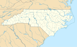
Moores Springs is located in North Carolina
Moores Springs
Moores Springs
Location within the state of North Carolina
Coordinates: 36°25′16″N 80°17′20″W / 36.42111°N 80.28889°W / 36.42111; -80.28889
CountryUnited States
StateNorth Carolina
CountyStokes
Time zoneUTC-5 (Eastern (EST))
 • Summer (DST)UTC-4 (EDT)

Moores Springs is an unincorporated community in Stokes County, North Carolina, United States, approximately five miles west-northwest of Danbury, near Hanging Rock State Park. It is becoming well known for its mountain biking trails and access to the Dan River.

The Matthew Moore House was added to the National Register of Historic Places in 1974.[1]

References

[edit]
  1. ^ "National Register Information System". National Register of Historic Places. National Park Service. July 9, 2010.


pFad - Phonifier reborn

Pfad - The Proxy pFad of © 2024 Garber Painting. All rights reserved.

Note: This service is not intended for secure transactions such as banking, social media, email, or purchasing. Use at your own risk. We assume no liability whatsoever for broken pages.


Alternative Proxies:

Alternative Proxy

pFad Proxy

pFad v3 Proxy

pFad v4 Proxy