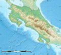
File:Costa Rica location map.svg
外观

此SVG文件的PNG预览的大小:666 × 600像素。 其他分辨率:267 × 240像素 | 533 × 480像素 | 853 × 768像素 | 1,137 × 1,024像素 | 2,274 × 2,048像素 | 1,148 × 1,034像素。
原始文件 (SVG文件,尺寸为1,148 × 1,034像素,文件大小:577 KB)
文件历史
点击某个日期/时间查看对应时刻的文件。
| 日期/时间 | 缩略图 | 大小 | 用户 | 备注 | |
|---|---|---|---|---|---|
| 当前 | 2022年3月30日 (三) 22:46 |  | 1,148 × 1,034(577 KB) | Sting | Error correction |
| 2022年3月30日 (三) 22:01 |  | 1,148 × 1,034(577 KB) | Sting | New map using new data | |
| 2021年11月4日 (四) 01:21 |  | 1,148 × 1,034(162 KB) | RoboQwezt0x7CB | removed non-existing waterbodies, particulary in the south of the country (probably an altitude render/clipping error), kept some that are hydroelectric plant's reservoirs | |
| 2008年7月30日 (三) 15:03 |  | 1,148 × 1,034(197 KB) | Sting | Standard colors ; - border | |
| 2008年6月13日 (五) 14:38 |  | 1,148 × 1,034(197 KB) | Sting | Several improvements | |
| 2008年6月12日 (四) 02:28 |  | 1,148 × 1,034(198 KB) | Sting | == Summary == {{Location|10|00|00|N|84|00|00|W|scale:2000000}} <br/> {{Information |Description={{en|Blank map of Costa Rica for geo-location purpose.<br/>''Note :'' The ''Isla del Coco'', out of the map, is not shown.<br/>Scale : 1:14, |
文件用途
以下31个页面使用本文件:
全域文件用途
以下其他wiki使用此文件:
- af.wikipedia.org上的用途
- an.wikipedia.org上的用途
- ar.wikipedia.org上的用途
- ast.wikipedia.org上的用途
- Universidá pa la Paz
- Páramo
- San Xosé (Costa Rica)
- Esferes de piedra de Costa Rica
- Módulu:Mapa de llocalización/datos/Costa Rica
- Módulu:Mapa de llocalización/datos/Costa Rica/usu
- Parque Morazán
- Aeropuertu La Managua
- Aeropuertu de Barra del Colorado
- Aeropuertu de Carrillo
- Aeropuertu de Coto 47
- Aeropuertu de Golfito
- Aeropuertu de Nosara
- Aeropuertu de Palmar Sur
- Aeropuertu de Puerto Jiménez
- Aeropuertu de Punta Islina
- Aeropuertu de Pérez Zeledón
- Aeropuertu de Tamarindu
- Golfu Dulce
- az.wikipedia.org上的用途
- ba.wikipedia.org上的用途
- be-tarask.wikipedia.org上的用途
- be.wikipedia.org上的用途
- bg.wikipedia.org上的用途
- bn.wikipedia.org上的用途
- bs.wikipedia.org上的用途
- ca.wikipedia.org上的用途
查看此文件的更多全域用途。

