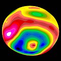
Súbor:Vesta-Elevation.jpg
Vzhľad
Vesta-Elevation.jpg (500 × 500 pixelov, veľkosť súboru: 43 KB, MIME typ: image/jpeg)
História súboru
Po kliknutí na dátum/čas uvidíte ako súbor vyzeral vtedy.
| Dátum/Čas | Náhľad | Rozmery | Používateľ | Komentár | |
|---|---|---|---|---|---|
| aktuálna | 07:57, 30. január 2006 |  | 500 × 500 (43 KB) | Arnomane | higher resolution |
| 17:56, 24. august 2005 |  | 200 × 200 (6 KB) | Vesta~commonswiki | * Description: A color-encoded elevation map of Vesta clearly shows the giant 460-kilometer diameter impact basin and "bull's-eye" central peak. The map was constructed from 78 Wide Field Planetary Camera 2 pictures. Surface topography was estimated by no |
Použitie súboru
Na tento súbor odkazuje nasledujúca stránka:
Globálne využitie súborov
Nasledovné ďalšie wiki používajú tento súbor:
- Použitie na als.wikipedia.org
- Použitie na ar.wikipedia.org
- Použitie na ca.wikipedia.org
- Použitie na cs.wikipedia.org
- Použitie na de.wikipedia.org
- Použitie na en.wikipedia.org
- Použitie na es.wikipedia.org
- Použitie na eu.wikipedia.org
- Použitie na fa.wikipedia.org
- Použitie na fi.wikipedia.org
- Použitie na fr.wikipedia.org
- Použitie na ko.wikipedia.org
- Použitie na lb.wikipedia.org
- Použitie na mk.wikipedia.org
- Použitie na oc.wikipedia.org
- Použitie na pt.wikipedia.org
- Použitie na ro.wikipedia.org
- Použitie na simple.wikipedia.org
- Použitie na sv.wikipedia.org
- Použitie na uk.wikipedia.org
- Použitie na www.wikidata.org
- Použitie na zh.wikipedia.org


