Torreneules
Appearance
| Torreneules | |
|---|---|
| Highest point | |
| Elevation | 2,713 m (8,901 ft) |
| Coordinates | 42°23′26.94″N 2°11′46.48″E / 42.3908167°N 2.1962444°E |
| Geography | |
| Location | Ripollès, Catalonia |
| Parent range | Pyrenees |
| Climbing | |
| First ascent | Unknown |
| Easiest route | From Queralbs |
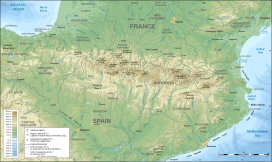
Torreneules is a mountain of Catalonia, Spain. Located in the Pyrenees, it has an elevation of 2,713 metres above sea level.[1]
See also
[edit]References
[edit]- ^ "Mapa Topogràfic de Catalunya". Institut Cartogràfic de Catalunya. Retrieved May 22, 2010..
