

Emneth: Difference between revisions
No edit summary Tags: Mobile edit Mobile web edit |
Entranced98 (talk | contribs) Adding short description: "Village in Norfolk, England", overriding automatically generated description |
||
| (23 intermediate revisions by 15 users not shown) | |||
| Line 1: | Line 1: | ||
{{Short description|Village in Norfolk, England}} |
|||
{{EngvarB|date=July 2016}} |
{{EngvarB|date=July 2016}} |
||
{{Use dmy dates|date=July 2016}} |
{{Use dmy dates|date=July 2016}} |
||
{{Infobox UK place |
{{Infobox UK place |
||
| official_name= |
| official_name= Emneth Primary |
||
| country= England |
| country= England |
||
| region= East of England |
| region= East of England |
||
| Line 9: | Line 10: | ||
| civil_parish= Emneth |
| civil_parish= Emneth |
||
| static_image_name = St Edmund, Emneth, Norfolk.jpg |
| static_image_name = St Edmund, Emneth, Norfolk.jpg |
||
| static_image_caption = |
| static_image_caption = St. Edmund's Church, Emneth |
||
| population = 2,617 |
| population = 2,617 |
||
| population_ref = |
| population_ref = [[2011 United Kingdom census|2011 Census]] |
||
| population_density= |
| population_density= |
||
| os_grid_reference= TF5103 |
| os_grid_reference= TF5103 |
||
| Line 22: | Line 23: | ||
| london_distance={{convert|99.6|mi|km}} |
| london_distance={{convert|99.6|mi|km}} |
||
}} |
}} |
||
'''Emneth''' ("even meadow" in old english) is a village and a civil parish in the English county of [[Norfolk]].<ref name=osexp228>Ordnance Survey (2006). ''OS Explorer Map 228 – March & Ely''. {{ISBN|0-319-23802-4}}</ref> The village is {{convert|58|mi|km}} west of [[Norwich]], {{convert|15.4|mi|km}} south-west of [[King's Lynn]] and {{convert|99.6|mi|km}} north of London. The nearest town is [[Wisbech]] which is {{convert|3.3|mi|km}} north-north-west of the village. The village lies to the south-west of the route of the [[A47 road|A47]]<ref>County A to Z Atlas, Street & Road maps Norfolk, page 230 {{ISBN|978-1-84348-614-5}}</ref> between [[Peterborough]] and [[King's Lynn]]. The nearest railway station is at [[Downham Market railway station|Downham Market]] for the [[Fen Line]] which runs between [[King's Lynn]] and [[Cambridge]]. The nearest airport is [[Cambridge International Airport]]. The parish of Emneth in the [[United Kingdom Census 2001|2001 census]], has a population of 2,466, increasing to 2,617 at the 2011 Census.<ref>{{cite web|url=http://www.neighbourhood.statistics.gov.uk/dissemination/LeadKeyFigures.do?a=7&b=11123221&c=Emneth&d=16&e=62&g=6449119&i=1001x1003x1032x1004&m=0&r=1&s=1440684847875&enc=1|title=Parish population 2011|access-date=27 August 2015}}</ref> For the purposes of local government, the parish falls within the [[Non-metropolitan district|district]] of [[King's Lynn and West Norfolk]]. |
|||
'''Emneth''' is a village and [[civil parish]] in the [[England|English]] county of [[Norfolk]]. The village is located {{convert|2.9|mi}} south-east of [[Wisbech]], {{convert|12|mi}} south-west of [[King's Lynn]] and {{convert|46|mi}} west of [[Norwich]], close to the course of the [[River Nene]]. |
|||
==Governance== |
|||
Emneth parish council has 12 members. The councillors elect a chair. |
|||
Emneth is part of the [[Wards and electoral divisions of the United Kingdom|electoral ward]] called Emneth with Outwell. The population of this ward taken at the 2011 Census was 4,700.<ref>{{cite web|url=http://www.neighbourhood.statistics.gov.uk/dissemination/LeadKeyFigures.do?a=7&b=13693585&c=Emneth&d=14&e=62&g=6449119&i=1001x1003x1032x1004&o=362&m=0&r=1&s=1440685214922&enc=1|title=Emneth with Outwell Ward population 2011|access-date=27 August 2015}}</ref> |
|||
==Description== |
|||
This [[The Fens|fenland]] village and parish is on the border with the county of [[Cambridgeshire]] in the south west of Norfolk. The village is located south of [[Walsoken]] and north of [[Outwell]]. Within the parish boundaries of Emneth there are also the settlements of Emneth Hungate and Holly End. |
|||
Over the years the meaning of the name Emneth<ref>A Popular Guide to Norfolk Place-names: by James Rye: Published by Larks press, Dereham, Norfolk, 2000 ; {{ISBN|0-948400-15-3}}</ref> has been debated. It is derived from old English and therefore probably has Saxon origins, and may have the meanings of ''smooth meadow'', ''junction of streams on the River Aemenan'', ''river confluence belonging to Eana'' or ''mowing grass meadow''. The ''Hungate'' suffix suggests this area may have been associated with the keeping or rearing of hounds. The village is not mentioned in the [[Domesday Book]]. This may well be because the village was valued with another parish and not named. There is evidence for activity in the parish from the Roman period and metal detectorists have found many medieval and post medieval finds. |
|||
==History== |
==History== |
||
Emneth's name is of [[Anglo-Saxon]] origin and derives from the [[Old English]] for Eana's meeting place or meadow.<ref> University of Nottingham. (2022). Retrieved December 28, 2022. http://kepn.nottingham.ac.uk/map/place/Norfolk/Emneth </ref> |
|||
The earliest mention of Emneth is in documents dating back to 1170 giving proof that a village was settled in the parish by this date. The parish church of [[Edmund the Martyr|Saint Edmund]]'s was built in the 12th century<ref name="srok4">Norfolk 2: Norfolk: North-west and South, By [[Nikolaus Pevsner]] and Bill Wilson, Emneth entry. 0-300-09657-7</ref> and extended dramatically in the 13th century.<ref name="srok4"/> It remains a large and imposing building. Other buildings from the [[medieval]] period which stood in the parish have been demolished. Hagbeach Hall a [[medieval]] hall was demolished in 1887, although its 17th-century stables remain and has been converted into a house. The medieval hall on the site of 17th-century Oxburgh Hall<ref name="srok4"/> was also demolished when the new hall was built. Other buildings have disappeared. Emneth was also recorded in a document in 1389 but this document's location has since been lost. Other sites have lost their names and sense of importance. A medieval moated site has been recorded and a seal used by [[Pope Innocent III]] to secure documents was found there along with other finds which included a medieval seals matrices, a horse harness pendant and medieval coins. Within the parish other more domestic sites with less status have also been identified. Medieval hearths were excavated along with many medieval finds including pottery, coins and personal objects. These include a spectacular strap end with the initials S and J. The number of items recovered at this site suggests that this was an area of substantial medieval settlement. |
|||
Emneth is not featured in the [[Domesday Book]] of 1086,<ref> Domesday Book. (1086). Retrieved December 28, 2022. https://opendomesday.org/map/ </ref> probably because in the late-Eleventh Century this area of [[Norfolk]] was still flooded. |
|||
==Landmarks== |
|||
| ⚫ | |||
This parish church built of stone sits on the bend of the main road. The tower, porch, and [[nave]] with its aisles and [[clerestory]] are all built in the perpendicular style.<ref name="srok5">The King's England series, NORFOLK, by Arthur Mee,Pub:Hodder and Stoughton,1972, page 87 Emneth, {{ISBN|0-340-15061-0}}</ref> There is a sanctus bellcote which has six bells,<ref>[http://dove.cccbr.org.uk/detail.php?searchString=Emneth&numPerPage=10&Submit=++Go++&searchAmount=%3D&searchMetric=cwt&sortBy=Place&sortDir=Asc&DoveID=EMNETH church bells]</ref> on the east gable of the nave. Crowning the nave, with its arcades of six bays is a 15th-century roof. Angels adorn its tiebeams and hammerbeams, and figures of the [[apostles]] with others carved in the wall posts. The [[chancel]] screen dates from the 15th century<ref name="srok5"/> and has the remains of old painting and [[gilding]] and in the north aisle windows in glass as old as the screen are of more angels. The chancel is 13th century<ref name="srok5"/> and the east window is a fine trinity of lancets reaching up to the roof. The [[Rood stair|rood-stairs]] are in a turret by the chancel arch, and there is a simple 15th-century<ref name="srok5"/> font. |
|||
The oldest memorials are coffin-lids, one with a border and a cross of leaves. Only the matrix is left of the {{convert|11|ft|m|adj=mid|-long}} brass of a cross-legged knight dressed in chain mail of about 1300.<ref name="srok5"/> Sir Thomas Hewar, who died in 1631,<ref name="srok5"/> planned for himself the fine alabaster tomb on which he lies in gold and white armour and a ruff, with his wife in a black gown and ruff. He had paid [[Nicholas Stone]] a London Mason the huge sum of £95<ref name="srok5"/> for the tomb in 1617. At their feet lies a sleeping child. |
|||
Emneth was the site of Hagbeach Hall, a medieval manor house demolished in 1887.<ref> Dennis, M. (2005). Retrieved December 28, 2022. https://www.heritage.norfolk.gov.uk/record-details?TNF254-Emneth-(Parish-Summary) </ref> |
|||
| ⚫ | |||
Emneth war memorial is located in the graveyard opposite the parish church. |
|||
==Geography== |
|||
===Emneth railway station=== |
|||
According to the [[2011 United Kingdom census|2011 Census]], Emneth has a population of 2,617 residents living in 1,150 households. Furthermore, the total area of the parish is {{convert|11.77|km2}}.<ref> Office for National Statistics. (2011). Retrieved December 28, 2022. https://www.nomisweb.co.uk/reports/localarea?compare=E04006309 </ref> |
|||
{{further|Emneth railway station}} |
|||
Emneth had a railway station which served the village, situated in Station Road and accessed from the village via Ladys Drove. The station was opened in 1848 as an extension of the East Anglian Railway's line from [[Watlington (Norfolk) railway station|Magdalen Road station]] (now known as Watlington) to [[Wisbech East railway station|Wisbech East]]. The station's location, like that of the neighbouring [[Middle Drove railway station|Middle Drove station]], was fairly rural and the line eventually closed in 1968, a casualty of the [[Beeching Axe]].<ref>{{Cite book | author=Oppitz, Leslie | title=Lost Railways of East Anglia (Lost Railways) | year=1999 | publisher=Countryside Books | location=Newbury, Berkshire | isbn=1-85306-595-1 | pages=19}}</ref> In October 1942, a hoard of [[Ancient Rome|Roman]] silver coins together with fragments of an urn in which they were stored was found near the station.<ref>{{cite journal|jstor=298046|journal=The Journal of Roman Studies|title=Roman Britain in 1945: I. Sites Explored: II. Inscriptions|volume=36, Parts 1 and 2|year=1946|pages=133–148|author=Wright}}</ref> Emneth's station building survived closure, and has since been converted into a private residence. |
|||
Emneth falls within the [[Constituencies of the Parliament of the United Kingdom|constituency]] of [[South West Norfolk (UK Parliament constituency)|South West Norfolk]] in the [[Parliament of the United Kingdom]]. For the purposes of local government, the parish falls within the [[Non-metropolitan district|district]] of [[King's Lynn and West Norfolk]]. |
|||
| ⚫ | |||
*Sir Thomas Howard {{which|date=January 2020}} is buried in Emneth. |
|||
The boundaries of the parish also includes the hamlets of Emneth Hungate and Holly End. |
|||
*The Reverend [[Wilbert Awdry]] (1911-1997) OBE, the author of [[The Railway Series]] books, and creator of [[Thomas the Tank Engine]], was Vicar of Emneth between 1953 and 1965. Many of his books were written in the old vicarage in Emneth. |
|||
*[[Tony Martin (farmer)|Tony Martin]], a farmer convicted of murder in 1999 after shooting a 16-year-old burglar, Fred Barras, at his farmhouse in [[Emneth Hungate]]. |
|||
| ⚫ | |||
Emneth's parish church is dedicated to [[Edmund the Martyr|Saint Edmund]] and dates from the Fifteenth Century. Built on the site of earlier Christian worship, the church is a good example of the architecture of the [[Perpendicular Gothic|Perpendicular style]]. St Edmund's has good examples of Eighteenth-Century stained glass installed by [[Clayton and Bell]] and [[William Wailes]]. One of the stained-glass roundels in the church depicts [[Thomas the Tank Engine]], in commemoration of its creator, [[Wilbert Awdry|Rev. W. V. Awdry]], who served as Vicar of Emneth from 1953 to 1965.<ref> Knott, S. (2022). Retrieved December 28, 2022. http://www.norfolkchurches.co.uk/emneth/emneth.htm </ref> St Edmund's also has a good example of a [[Bell-cot|bell-cote]] with six bells, and Angels and the [[Apostles in the New Testament|Apostles]] carved into the [[Tie (engineering)|tie-beam]]s and [[hammerbeam]]s. |
|||
==Transport== |
|||
[[Emneth railway station]] opened in 1848 as a stop on the [[Bramley Line]] between [[Watlington railway station|Watlington]] and [[Peterborough railway station]]. The station closed in 1968 as a result of the [[Beeching cuts]], however, the railway infrastructure still remains as a private residence. Today, the nearest railway station is at [[Downham Market railway station|Downham Market]] for the [[Fen Line]] between [[King's Lynn]] and [[Peterborough]]. |
|||
Emneth is bisected by the [[A47 road|A47]] between [[Birmingham]] and [[Lowestoft]] and the nearest airport is [[Cambridge International Airport]]. |
|||
| ⚫ | |||
* [[Sir Henry Peyton, 2nd Baronet]] (1779–1854)- English politician{{citation needed|date=December 2022}} |
|||
* [[Wilbert Awdry|Rev. W. V. Awdry]] (1911–1997)- English clergyman and children's author |
|||
* [[Tony Martin (farmer)|Tony Martin]] (born 1944)- English farmer |
|||
| ⚫ | |||
Emneth's war memorial takes the form of a stone column topped with a small [[Celtic cross]] located inside St. Edmund's Churchyard. The memorial lists the following names for the [[First World War]]: |
|||
{{colbegin}} |
|||
* Capt. John A. Markham (1887–1915), 1st Battalion, [[East Yorkshire Regiment]] |
|||
* 2nd-Lt. Leonard W. Brooks (1885–1917), [[No. 2 Squadron RAF|No. 2 Squadron RFC]] |
|||
* Sgt. John H. Claxton (d.1915), 1st Battalion, [[Royal Norfolk Regiment]] |
|||
* Sgt. Frederick Neal (1883–1915), 1st Battalion, [[Suffolk Regiment]] |
|||
* Sgt. Frederick Day (d.1916), 2nd Battalion, Suffolk Regiment |
|||
* Cpl. Robert Lines (d.1916), [[Royal Field Artillery]] att. [[11th (Northern) Division]] |
|||
* L-Cpl. Archibald B. Crofts (1890–1916), 2nd Battalion, [[King's Royal Rifle Corps]] |
|||
* L-Cpl. Ernest A. Edwards (1891–1917), 2/4th Battalion, [[Lincolnshire Regiment]] |
|||
* L-Cpl. Reginald V. Green (1897–1918), 1st Battalion, [[Middlesex Regiment]] |
|||
* Dvr. John Chase (d.1918), 72nd Brigade, Royal Field Artillery |
|||
* Pte. George Laws (1892–1918), 1st Battalion, [[Bedfordshire Regiment]] |
|||
* Pte. Len Brown (d.1917), 1/1st Battalion, [[Cambridgeshire Regiment]] |
|||
* Pte. Oliver Hunter (1898–1918), 1/1st Battalion, Cambridgeshire Regiment |
|||
* Pte. Arthur Roper (1895–1915), 1/1st Battalion, Cambridgeshire Regiment |
|||
* Pte. George W. Hurst (1900–1919), 8th Battalion, [[East Surrey Regiment]] |
|||
* Pte. Harry Glover (d.1916), 4th Battalion, [[Grenadier Guards]] |
|||
* Pte. Stanley H. C. Long (1895–1917), 2nd Battalion, [[Hampshire Regiment]] |
|||
* Pte. Thomas Sharp (1888–1918), Agricultural Company, [[Labour Corps (British Army)|Labour Corps]] |
|||
* Pte. Samuel F. Balderson (1895–1916), 7th Battalion, Lincolnshire Regiment |
|||
* Pte. Frank Moyses (d.1918), 3rd Company, [[Machine Gun Corps]] |
|||
* Pte. Samuel Stokes (1895–1917), 25th Company, Machine Gun Corps |
|||
* Pte. Charles W. Brewington (1896–1917), 16th (Public Schools) Battalion, Middlesex Regiment |
|||
* Pte. William Hanslip (1881–1916), 9th Battalion, Royal Norfolk Regiment |
|||
* Pte. Sydney E. Killingsworth (d.1918), 2nd Battalion, [[Northamptonshire Regiment]] |
|||
* Pte. Arthur Hurst (1893–1918), 5th Battalion, Northamptonshire Regiment |
|||
* Pte. William B. Smith [[Military Medal|MM]] (1899–1916), 2nd Battalion, Suffolk Regiment |
|||
* Pte. William Jackson (d.1917), 5th Battalion, Suffolk Regiment |
|||
{{colend}} |
|||
And, the following for the [[Second World War]]: |
|||
{{colbegin}} |
|||
* Cpt. Harold M. R. Norton (1922–1945), [[Glider Pilot Regiment]] |
|||
* F/O. Arthur R. Ludlow (1922–1943), [[No. 44 Squadron RAF]] |
|||
* Sgt. Neville W. Carlile (1917–1940), [[No. 82 Squadron RAF]] |
|||
* L-Cpl. Walter H. White (1913–1944), [[Royal Military Police]] |
|||
* Dvr. Joseph L. Mason (d.1944), [[Royal Army Medical Corps]] |
|||
* Dvr. Frank Farrow (1918–1944), [[Royal Army Service Corps]] |
|||
* Gnr. Robert Bruce (1919–1944), [[Suffolk Yeomanry|55th (Suffolk Yeomanry) Anti-Tank Regiment]], [[Royal Artillery]] |
|||
* Pte. Charles H. Baxter (1918–1942), 2nd Battalion, [[Cambridgeshire Regiment]] |
|||
* Pte. Leslie Wabe (1906–1944), 7th Battalion, [[Cheshire Regiment]] |
|||
* Pte. Richard R. Neal (1920–1943), 6th Battalion, [[Royal Norfolk Regiment]] |
|||
* Pte. Percy I. White (1909–1944), 2nd Battalion, [[Suffolk Regiment]] |
|||
* Vera M. Matthews (1920–1944), [[Women's Royal Air Force]]<ref> Brown, C. (2022). Retrieved December 28, 2022. http://www.roll-of-honour.com/Norfolk/EmnethMemorial.html </ref> |
|||
{{colend}} |
|||
==Gallery== |
==Gallery== |
||
| Line 60: | Line 109: | ||
==References== |
==References== |
||
{{Reflist}} |
{{Reflist}} |
||
==Further reading== |
|||
[[Arthur Mee|Mee, A]]. (1972). ''The King's England: Norfolk''. London: Hodder and Stoughton, p.87. {{ISBN|0-340-15061-0}} |
|||
==External links== |
==External links== |
||
Latest revision as of 15:41, 16 October 2024
| Emneth Primary | |
|---|---|
 St. Edmund's Church, Emneth | |
 Emneth Primary Location within Norfolk | |
| Population | 2,617 2011 Census |
| OS grid reference | TF5103 |
| • London | 99.6 miles (160.3 km) |
| Civil parish |
|
| District | |
| Shire county | |
| Region | |
| Country | England |
| Sovereign state | United Kingdom |
| Post town | WISBECH |
| Postcode district | PE14 |
| Dialling code | 01945 |
| Police | Norfolk |
| Fire | Norfolk |
| Ambulance | East of England |
| UK Parliament | |
Emneth is a village and civil parish in the English county of Norfolk. The village is located 2.9 miles (4.7 km) south-east of Wisbech, 12 miles (19 km) south-west of King's Lynn and 46 miles (74 km) west of Norwich, close to the course of the River Nene.
History
[edit]Emneth's name is of Anglo-Saxon origin and derives from the Old English for Eana's meeting place or meadow.[1]
Emneth is not featured in the Domesday Book of 1086,[2] probably because in the late-Eleventh Century this area of Norfolk was still flooded.
Emneth was the site of Hagbeach Hall, a medieval manor house demolished in 1887.[3]
Geography
[edit]According to the 2011 Census, Emneth has a population of 2,617 residents living in 1,150 households. Furthermore, the total area of the parish is 11.77 square kilometres (4.54 sq mi).[4]
Emneth falls within the constituency of South West Norfolk in the Parliament of the United Kingdom. For the purposes of local government, the parish falls within the district of King's Lynn and West Norfolk.
The boundaries of the parish also includes the hamlets of Emneth Hungate and Holly End.
St Edmund's Church
[edit]Emneth's parish church is dedicated to Saint Edmund and dates from the Fifteenth Century. Built on the site of earlier Christian worship, the church is a good example of the architecture of the Perpendicular style. St Edmund's has good examples of Eighteenth-Century stained glass installed by Clayton and Bell and William Wailes. One of the stained-glass roundels in the church depicts Thomas the Tank Engine, in commemoration of its creator, Rev. W. V. Awdry, who served as Vicar of Emneth from 1953 to 1965.[5] St Edmund's also has a good example of a bell-cote with six bells, and Angels and the Apostles carved into the tie-beams and hammerbeams.
Transport
[edit]Emneth railway station opened in 1848 as a stop on the Bramley Line between Watlington and Peterborough railway station. The station closed in 1968 as a result of the Beeching cuts, however, the railway infrastructure still remains as a private residence. Today, the nearest railway station is at Downham Market for the Fen Line between King's Lynn and Peterborough.
Emneth is bisected by the A47 between Birmingham and Lowestoft and the nearest airport is Cambridge International Airport.
Notable residents
[edit]- Sir Henry Peyton, 2nd Baronet (1779–1854)- English politician[citation needed]
- Rev. W. V. Awdry (1911–1997)- English clergyman and children's author
- Tony Martin (born 1944)- English farmer
War memorial
[edit]Emneth's war memorial takes the form of a stone column topped with a small Celtic cross located inside St. Edmund's Churchyard. The memorial lists the following names for the First World War:
- Capt. John A. Markham (1887–1915), 1st Battalion, East Yorkshire Regiment
- 2nd-Lt. Leonard W. Brooks (1885–1917), No. 2 Squadron RFC
- Sgt. John H. Claxton (d.1915), 1st Battalion, Royal Norfolk Regiment
- Sgt. Frederick Neal (1883–1915), 1st Battalion, Suffolk Regiment
- Sgt. Frederick Day (d.1916), 2nd Battalion, Suffolk Regiment
- Cpl. Robert Lines (d.1916), Royal Field Artillery att. 11th (Northern) Division
- L-Cpl. Archibald B. Crofts (1890–1916), 2nd Battalion, King's Royal Rifle Corps
- L-Cpl. Ernest A. Edwards (1891–1917), 2/4th Battalion, Lincolnshire Regiment
- L-Cpl. Reginald V. Green (1897–1918), 1st Battalion, Middlesex Regiment
- Dvr. John Chase (d.1918), 72nd Brigade, Royal Field Artillery
- Pte. George Laws (1892–1918), 1st Battalion, Bedfordshire Regiment
- Pte. Len Brown (d.1917), 1/1st Battalion, Cambridgeshire Regiment
- Pte. Oliver Hunter (1898–1918), 1/1st Battalion, Cambridgeshire Regiment
- Pte. Arthur Roper (1895–1915), 1/1st Battalion, Cambridgeshire Regiment
- Pte. George W. Hurst (1900–1919), 8th Battalion, East Surrey Regiment
- Pte. Harry Glover (d.1916), 4th Battalion, Grenadier Guards
- Pte. Stanley H. C. Long (1895–1917), 2nd Battalion, Hampshire Regiment
- Pte. Thomas Sharp (1888–1918), Agricultural Company, Labour Corps
- Pte. Samuel F. Balderson (1895–1916), 7th Battalion, Lincolnshire Regiment
- Pte. Frank Moyses (d.1918), 3rd Company, Machine Gun Corps
- Pte. Samuel Stokes (1895–1917), 25th Company, Machine Gun Corps
- Pte. Charles W. Brewington (1896–1917), 16th (Public Schools) Battalion, Middlesex Regiment
- Pte. William Hanslip (1881–1916), 9th Battalion, Royal Norfolk Regiment
- Pte. Sydney E. Killingsworth (d.1918), 2nd Battalion, Northamptonshire Regiment
- Pte. Arthur Hurst (1893–1918), 5th Battalion, Northamptonshire Regiment
- Pte. William B. Smith MM (1899–1916), 2nd Battalion, Suffolk Regiment
- Pte. William Jackson (d.1917), 5th Battalion, Suffolk Regiment
And, the following for the Second World War:
- Cpt. Harold M. R. Norton (1922–1945), Glider Pilot Regiment
- F/O. Arthur R. Ludlow (1922–1943), No. 44 Squadron RAF
- Sgt. Neville W. Carlile (1917–1940), No. 82 Squadron RAF
- L-Cpl. Walter H. White (1913–1944), Royal Military Police
- Dvr. Joseph L. Mason (d.1944), Royal Army Medical Corps
- Dvr. Frank Farrow (1918–1944), Royal Army Service Corps
- Gnr. Robert Bruce (1919–1944), 55th (Suffolk Yeomanry) Anti-Tank Regiment, Royal Artillery
- Pte. Charles H. Baxter (1918–1942), 2nd Battalion, Cambridgeshire Regiment
- Pte. Leslie Wabe (1906–1944), 7th Battalion, Cheshire Regiment
- Pte. Richard R. Neal (1920–1943), 6th Battalion, Royal Norfolk Regiment
- Pte. Percy I. White (1909–1944), 2nd Battalion, Suffolk Regiment
- Vera M. Matthews (1920–1944), Women's Royal Air Force[6]
Gallery
[edit]-
 The old station house, now a private house
 -
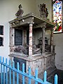 Tomb Chest of Sir Thomas Hewar, by Nicholas Stone


References
[edit]- ^ University of Nottingham. (2022). Retrieved December 28, 2022. http://kepn.nottingham.ac.uk/map/place/Norfolk/Emneth
- ^ Domesday Book. (1086). Retrieved December 28, 2022. https://opendomesday.org/map/
- ^ Dennis, M. (2005). Retrieved December 28, 2022. https://www.heritage.norfolk.gov.uk/record-details?TNF254-Emneth-(Parish-Summary)
- ^ Office for National Statistics. (2011). Retrieved December 28, 2022. https://www.nomisweb.co.uk/reports/localarea?compare=E04006309
- ^ Knott, S. (2022). Retrieved December 28, 2022. http://www.norfolkchurches.co.uk/emneth/emneth.htm
- ^ Brown, C. (2022). Retrieved December 28, 2022. http://www.roll-of-honour.com/Norfolk/EmnethMemorial.html
Further reading
[edit]Mee, A. (1972). The King's England: Norfolk. London: Hodder and Stoughton, p.87. ISBN 0-340-15061-0
External links
[edit]![]() Media related to Emneth at Wikimedia Commons
Media related to Emneth at Wikimedia Commons