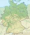
File:Relief Map of Germany.png

Original file (1,000 × 1,185 pixels, file size: 1.71 MB, MIME type: image/png)
Captions
Captions
Summary
[edit]| DescriptionRelief Map of Germany.png |
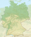
English: Relief map of Germany
Equirectangular projection, N/S stretching 150 %. Geographic limits of the map:
|
| Date | |
| Source |
|
| Author | derivative work Виктор_В |
| Other versions |
Derivative works of this file: Relief Map of Germany, Black Forest.png Bundesrepublik Deutschland (vor 1990 nur West-Deutschland):
Deutsche Demokratische Republik (mit BRD im Ausschnitt):
Ostdeutschland (vor 1990 Deutsche Demokratische Republik):
Deutschland zwischen Mai 1945 und Oktober 1949:
Thematisch:
Deutsches Reich (1918–1945) (best used with this template (de)):
|
Licensing
[edit]- You are free:
- to share – to copy, distribute and transmit the work
- to remix – to adapt the work
- Under the following conditions:
- attribution – You must give appropriate credit, provide a link to the license, and indicate if changes were made. You may do so in any reasonable manner, but not in any way that suggests the licensor endorses you or your use.
- share alike – If you remix, transform, or build upon the material, you must distribute your contributions under the same or compatible license as the original.
File history
Click on a date/time to view the file as it appeared at that time.
| Date/Time | Thumbnail | Dimensions | User | Comment | |
|---|---|---|---|---|---|
| current | 12:00, 21 October 2013 |  | 1,000 × 1,185 (1.71 MB) | Lencer (talk | contribs) | + border of Bremerhaven |
| 11:59, 21 October 2013 |  | 1,000 × 1,185 (1.71 MB) | Lencer (talk | contribs) | + border of Bremerhaven | |
| 17:48, 28 August 2010 |  | 1,000 × 1,185 (1.71 MB) | Виктор В (talk | contribs) | Рельеф дна | |
| 16:40, 28 August 2010 |  | 1,000 × 1,185 (1.65 MB) | Виктор В (talk | contribs) | мелкие исправления | |
| 12:03, 28 August 2010 |  | 1,000 × 1,185 (1.68 MB) | Виктор В (talk | contribs) | == {{int:filedesc}} == {{Information |Description={{en|Relief map of Germany}} Equirectangular projection, N/S stretching 150 %. Geographic limits of the map: * N: 55.1° N * S: 47.2° N * W: 5.5° E * E: |
You cannot overwrite this file.
File usage on Commons
The following 77 pages use this file:
- File:Baden-Württemberg in Germany (relief).svg
- File:Baden-Württemberg in Germany (relief) (shade).svg
- File:Baden-Württemberg in Germany (relief) (shade) (special marker).svg
- File:Bavaria in Germany (relief).svg
- File:Bavaria in Germany (relief) (shade).svg
- File:Bavaria in Germany (relief) (shade) (special marker).svg
- File:Berlin in Germany (relief).svg
- File:Berlin in Germany (relief) (shade).svg
- File:Berlin in Germany (relief) (shade) (special marker).svg
- File:Brandenburg in Germany (relief).svg
- File:Brandenburg in Germany (relief) (shade).svg
- File:Brandenburg in Germany (relief) (shade) (special marker).svg
- File:Bremen in Germany (relief).svg
- File:Bremen in Germany (relief) (shade).svg
- File:Bremen in Germany (relief) (shade) (special marker).svg
- File:Deutschland Autobahnen.svg
- File:East-West-Germany-October 1949-July 1952.svg
- File:East Germany location map.svg
- File:Germany, Federal Republic of location map 23 May 1949 - 6 Oct 1949.svg
- File:Germany, Federal Republic of location map April 1952 - August 1955.svg
- File:Germany, Federal Republic of location map December 1950 - April 1952.svg
- File:Germany, Federal Republic of location map January 1957 - October 1990.svg
- File:Germany, Federal Republic of location map October 1949 - November 1950.svg
- File:Germany, Federal Republic of location map September 1955 - December 1956.svg
- File:Germany, German Democratic Republic location map January 1957 - October 1990.svg
- File:Germany, German Democratic Republic location map July 1952 - January 1957.svg
- File:Germany, German Democratic Republic location map October 1949 - July 1952.svg
- File:Germany, German Democratic Republic location map w·o FRG July 1952 - October 1990.svg
- File:Germany, German Democratic Republic location map w·o FRG October 1949 - June 1952.svg
- File:Germany, location map (SBZ perspective) 23 May 1949 - 6 Oct 1949.svg
- File:Germany2 location map.svg
- File:Germany location map.svg
- File:Germany location map 23 April 1949 - 22 May 1949.svg
- File:Germany location map 8 Jun 1947 - 22 Apr 1949.svg
- File:Germany location map April 1992 - July 1992.svg
- File:Germany location map August 1992 - June 1993.svg
- File:Germany location map July 1993 - December 2009.svg
- File:Germany location map October 1990 - March 1992.svg
- File:Germany location map labeled 8 Jun 1947 - 22 Apr 1949.svg
- File:Hamburg in Germany (relief).svg
- File:Hamburg in Germany (relief) (shade).svg
- File:Hamburg in Germany (relief) (shade) (special marker).svg
- File:Hesse in Germany (relief).svg
- File:Hesse in Germany (relief) (shade).svg
- File:Hesse in Germany (relief) (shade) (special marker).svg
- File:Lage Freiberg in Deutschland.png
- File:Lower Saxony in Germany (relief).svg
- File:Lower Saxony in Germany (relief) (shade).svg
- File:Lower Saxony in Germany (relief) (shade) (special marker).svg
- File:Mecklenburg-Vorpommern in Germany (relief).svg
- File:Mecklenburg-Vorpommern in Germany (relief) (shade).svg
- File:Mecklenburg-Vorpommern in Germany (relief) (shade) (special marker).svg
- File:North Rhine-Westphalia in Germany (relief).svg
- File:North Rhine-Westphalia in Germany (relief) (shade).svg
- File:North Rhine-Westphalia in Germany (relief) (shade) (special marker).svg
- File:Relief Map of Germany, Black Forest.png
- File:Relief Map of Germany.png
- File:Relief Map of Germany.svg
- File:Rhineland-Palatinate in Germany (relief).svg
- File:Rhineland-Palatinate in Germany (relief) (shade).svg
- File:Rhineland-Palatinate in Germany (relief) (shade) (special marker).svg
- File:Saarland in Germany (relief).svg
- File:Saarland in Germany (relief) (shade).svg
- File:Saarland in Germany (relief) (shade) (special marker).svg
- File:Saxony-Anhalt in Germany (relief).svg
- File:Saxony-Anhalt in Germany (relief) (shade).svg
- File:Saxony-Anhalt in Germany (relief) (shade) (special marker).svg
- File:Saxony in Germany (relief).svg
- File:Saxony in Germany (relief) (shade).svg
- File:Saxony in Germany (relief) (shade) (special marker).svg
- File:Schleswig-Holstein in Germany (relief).svg
- File:Schleswig-Holstein in Germany (relief) (shade).svg
- File:Schleswig-Holstein in Germany (relief) (shade) (special marker).svg
- File:Thuringia in Germany (relief).svg
- File:Thuringia in Germany (relief) (shade).svg
- File:Thuringia in Germany (relief) (shade) (special marker).svg
- Template:Germany location map/other versions
File usage on other wikis
The following other wikis use this file:
- Usage on als.wikipedia.org
- Usage on am.wikipedia.org
- Usage on ar.wikipedia.org
- Usage on bn.wikipedia.org
- Usage on bs.wikipedia.org
- Usage on ca.wikipedia.org
- Usage on ce.wikipedia.org
- Usage on ckb.wikipedia.org
- Usage on da.wikipedia.org
- Usage on de.wikipedia.org
- Usage on diq.wikipedia.org
- Usage on en.wikipedia.org
- Usage on eo.wikipedia.org
- Usage on es.wikipedia.org
- Usage on fo.wikipedia.org
- Usage on fr.wikipedia.org
- Usage on fy.wikipedia.org
- Usage on hi.wikipedia.org
- Usage on hu.wikipedia.org
- Usage on hy.wikipedia.org
- Usage on ilo.wikipedia.org
- Usage on inh.wikipedia.org
- Usage on it.wikivoyage.org
View more global usage of this file.
Metadata
This file contains additional information such as Exif metadata which may have been added by the digital camera, scanner, or software program used to create or digitize it. If the file has been modified from its original state, some details such as the timestamp may not fully reflect those of the original file. The timestamp is only as accurate as the clock in the camera, and it may be completely wrong.
| Horizontal resolution | 35.43 dpc |
|---|---|
| Vertical resolution | 35.43 dpc |
| Software used |
