File:Europe map Napoleon 1811.svg
From Wikimedia Commons, the free media repository
Jump to navigation
Jump to search

Size of this PNG preview of this SVG file: 415 × 422 pixels. Other resolutions: 236 × 240 pixels | 472 × 480 pixels | 755 × 768 pixels | 1,007 × 1,024 pixels | 2,014 × 2,048 pixels.
Original file (SVG file, nominally 415 × 422 pixels, file size: 89 KB)
File information
Structured data
Captions
Captions
Add a one-line explanation of what this file represents
The factual accuracy of this map or the file name is disputed.
Reason: The overly-straight West coast of Ireland is clearly a glitch. This is Ireland: File:Ireland_(MODIS).jpg |  |
The factual accuracy of this map or the file name is disputed.
Reason: The Duchy of Warsaw must be re-drawn to an accurate shape according to File:Duchy of Warsaw and Republic of Danzig.JPG |  |
Summary
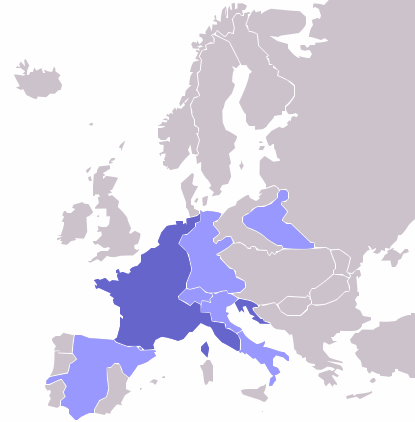
[edit]| DescriptionEurope map Napoleon 1811.svg | Map of the w:First French Empire and satellite states, with w:1811 borders. Created by User:OwenBlacker from Image:Europe blank map.png, therefore they are the source. |
| Date | (UTC) |
| Source | |
| Author |
|
| Other versions | File:Europe map Napoleon 1811.png |
Licensing
[edit]| Public domainPublic domainfalsefalse |
| I, the copyright holder of this work, release this work into the public domain. This applies worldwide. In some countries this may not be legally possible; if so: I grant anyone the right to use this work for any purpose, without any conditions, unless such conditions are required by law. |
Original upload log
[edit]This image is a derivative work of the following images:
- File:Europe_map_Napoleon_1811.png licensed with PD-self
- 2006-10-16T00:53:12Z Deltabeignet 415x422 (13615 Bytes) Corrected status of Illyrian provinces.
- 2005-08-21T00:51:11Z OwenBlacker 415x422 (11762 Bytes) Map of the [[w:First French Empire]] and satellite states, with [[w:1811]] borders. Created by [[User:OwenBlacker]] from [[:Image:Europe blank map.png]] {{GFDL}} {{cc-by-sa-2.0-uk}}
Uploaded with derivativeFX
| Annotations InfoField | This image is annotated: View the annotations at Commons |
90
238
123
112
415
422
Main French Empire
60
330
93
84
415
422
Kingdom of Spain (areas taken over by French Empire)
182
205
56
82
415
422
Confederation of the Rhine (French Vassal)
255
199
51
49
415
422
Duchy of Warsaw (French Vassal) Note: the shape in this image is incorrect.
181
288
31
17
415
422
Swiss Confederation (French Vassal)
213
293
25
34
415
422
Kingdom of Italy (French Vassal)
242
332
44
50
415
422
Kingdom of Naples (French Ally)
237
296
33
31
415
422
Venice region (Part of French Empire)
File history
Click on a date/time to view the file as it appeared at that time.
| Date/Time | Thumbnail | Dimensions | User | Comment | |
|---|---|---|---|---|---|
| current | 23:14, 2 May 2009 |  | 415 × 422 (89 KB) | Mnmazur (talk | contribs) | {{Information |Description=Map of the w:First French Empire and satellite states, with w:1811 borders. Created by User:OwenBlacker from Image:Europe blank map.png, therefore they are the source. |Source=*[[:File:Europe_map_Napoleon_1811.p |
You cannot overwrite this file.
File usage on Commons
The following page uses this file:
File usage on other wikis
The following other wikis use this file:
- Usage on ba.wikipedia.org
- Usage on es.wikipedia.org
- Usage on et.wikipedia.org
- Usage on fr.wikipedia.org
- Usage on hi.wikipedia.org
- Usage on hu.wikipedia.org
- Usage on hy.wikipedia.org
- Usage on no.wikipedia.org
- Usage on pl.wikipedia.org
- Usage on ru.wikipedia.org
- Usage on sr.wikipedia.org
- Usage on sv.wikipedia.org
- Usage on tl.wikipedia.org
- Usage on tt.wikipedia.org
- Usage on uk.wikipedia.org
- Usage on yo.wikipedia.org
- Usage on zh-min-nan.wikipedia.org